
South Cheshire Way

![]()
South Cheshire Way
This is a 34 mile walk from Grindley Brook (near Whitchurch) to Mow Cop. It therefore links the South ends of the Sandstone Trail and the Gritstone Trail. Adding in walks to train stations (Whitchurch and Kidsgrove) makes the walk nearly 40 miles long.
The path spans OS landranger sheets 117 (Chester and Wrexham) and 118 (Stoke-on-Trent and Macclesfield). Alternatively use Explorer maps 268 and 257. The route is well waymarked (yellow arrow with "SCW") but there are a few places where the field boundaries on the explorer maps will avoid confusion. The way overlaps with parts of the Bishop Bennet Way and the Crewe and Nantwich circular walk so these waymarks may also be followed in places.
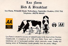
I stayed at Lea Farm near Wybunbury - around 300 yards off the route down an easy road (01270 841429). Bed and breakfast at £28. There is also a pub/hotel in Weston near the centre of the route even closer to the trail. Wybunbury has the Swan Inn which advertises accommodation. This is around a mile off the route.
The route has few outstanding moments, passing mostly through low lying farmland. The Sandstone and, especially, Gritstone, trails provide longer views at the expense of more climbing. Best moments are probably the view to Marbury church across the mere and the view from the finish at Mow Cop (well this would be a highlight, but see pictures below). On the other hand the trail is easy to follow and is less eroded than either of the other two and the way is always pleasant. The lack of climbing makes for fast progress - for each of the two days I walked I started around 8:45 each day and had finished for 3:30pm; at 20 miles per day that's almost 3mph without much effort.
Whilst approaching Crewe by train ready to start the first day thick mist set in. This worsened as we passed through Nantwich and I was starting to plan diversions by road in order to be able to find the route. Approaching Whitchurch, however, the fog went away and the sun came out. The weather stayed sunny, if icy in places, for the whole first day. The second day was grey and breezier but, contrary to the weather forecast, stayed mostly dry. Earlier rain had left the way very muddy though - I sunk up to the knee once and over my ankle on half-a-dozen occasions - despite trying to take reasonable diversions.
 |
The Start By the petrol station in Grindley Brook! The sign says South Cheshire Way - Mow Cop 53km. The distance sounds more impressive in km. |
 |
Shropshire Union Canal Llangollen branch of the canal near Grindley Brook. I haven't even changed out of my trainers yet. |
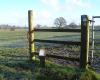 |
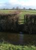
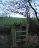
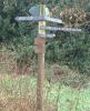
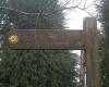
Stile in Fields You'll see a lot of all of these: fields, stiles and direction markers with "SCW". This could be viewed as 'typical' scenery for the walk. |
| Wicksted Old Hall We have just come from the hall and will turn towards Marbury here. |
|
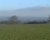
| Peckforton Hills The Peckforton hills dominate west Cheshire. On the Sandstone Trail we go right over them. On the South Cheshire Way they make a nice backdrop for this part of the walk. |
|
 |
Descent to Marbury Ignoring the hills to the left we descend towards Marbury church. |
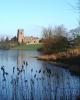 |
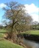
Marbury Church This is Marbury Church and Marbury Big Mere. |
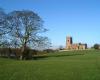 |
Marbury Church Well, it was one of the outstanding bits of the first day so it justifies a few pictures. |
 |
Wrenbury Church More churches and fields - you can't see the stile (I'm sitting on it) or the "SCW" marker (it's behind you). |
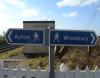 |
Railway near Aston Presumably this sign makes sure you don't inadvertently walk down the middle of the train track. Nantwich Brewery is just the other side of the tracks. |
 |
Austin's Bridge Over the main line of the Shropshire Union Canal |
 |
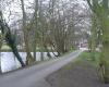
Shropshire Union Canal Main line from Austin's Bridge. Sunshine. Fluffy white clouds. Ahhhh. A bit off to the left is the Secret Nuclear Bunker. But don't tell anyone - it's a secret. |
 |
Oh yes ... Fields, stiles, "SCW" markers and, of course, mud. That's the other thing we'll see a lot of. I can bypass this pool easily enough but things get trickier later. |
 |
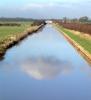
River Weaver Stopped here for a late lunch. |
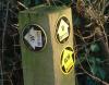 |
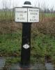
Mysterious Trails What are the B and W Trails? Joined these to near Lea Forge then turned off. W for Wybunbury maybe? But B? Haven't a clue. |
 |
Lea Farm I stopped here for the night. |
 |
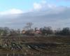
Fields, Stiles and SCW Markers Rather more mud today now that the frost has cleared. |
 |
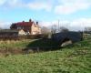
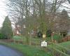
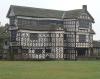
Haslington Hall Pretty and no stiles. |
 |
Trent and Mersey Canal Hang on Preston Brook is near home - I'm going the wrong way. |
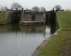 |
Locks They seem to come in pairs on this canal. |
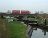 |
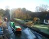
Old and New The picturesque Trent and Mersey Canal locks and the somewhat less picturesque M6. Rapid progress is possible along the canal bank. |
 |
Little Moreton Hall It really is that crooked. A short descent to the canal follows. |
 |
Climb to Mow Cop On the other side of the canal we climb 200m in about a mile. That's probably more climb than in the rest of the walk put together. Never mind, the views will be worth it ... |
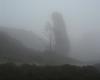 |
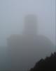
Old Man of Mow This is taken from, perhaps, 20m away. Misty isn't it? |
 |
The end So 53km done. Slightly confusingly there is an SCW marker pointing right here. |
 |
Mow Cop Castle I think the trail really ends here. Time to descend to Kidsgrove train station. |
 |
Souvenir Other people buy rock, donkeys with hats, postcards ... I have to be different. It felt bigger than this I can tell you. |
This document
maintained by rb-jarvis@woodhouseclose.free-online.co.uk.
Material Copyright © 2001 Richard Jarvis